My contribution Used Fortran and GrADS for processing, statistical analysis and visualization within a six-author thesis.
Snow, ocean and atmosphere
Research and coursework examining snowfall, sea surface temperature, circulation and sea ice through regression, composites, EOF and time-series methods.
Fortran / GrADS / MATLAB
Details & examples
Problem
Examine how Jeonju winter snow varies with global ocean–atmosphere conditions.
Inputs
Jeonju snow observations and NOAA ocean/atmosphere reanalysis.
My role
Used Fortran and GrADS for processing, statistical analysis and visualization within a six-author thesis.
Processing & operations
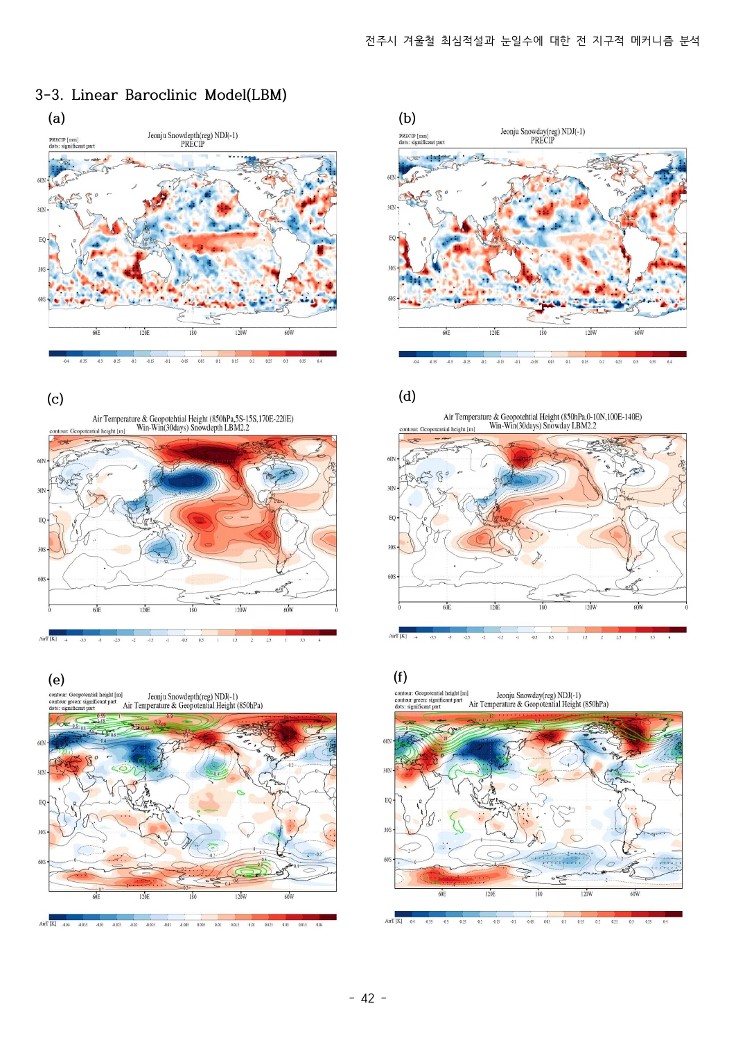
Use seasonal means and lagged regression to examine winter-snow relationships. The coauthored final thesis also compares LBM response experiments; this does not attribute all modeling to me. Other coursework methods are separately archived.
Outputs & evidence
Research maps, time series and the 2021 coauthored undergraduate thesis.
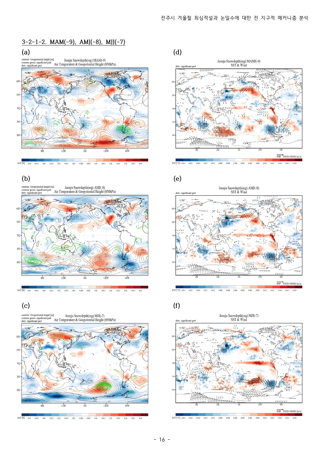
2021 coauthored thesis · Figure 3
Scope Full scientific replication remains unverified.
My contribution Developed public-data integration, typed agent tools and inspectable itinerary rules.
Public data → inspectable travel drafts
Tourism, marine, weather and transport evidence connected through eight typed tools. One- to three-day car or walking drafts across 29 forecast-linked scopes.
Python / FastAPI / Ollama / LangGraph
Details & examples
Problem
Travel drafts need dated evidence and visible access constraints across multiple data sources.
Inputs
TourAPI tourism records, marine forecasts, weather and transport references.
My role
Developed public-data integration, typed agent tools and inspectable itinerary rules.
Processing & operations
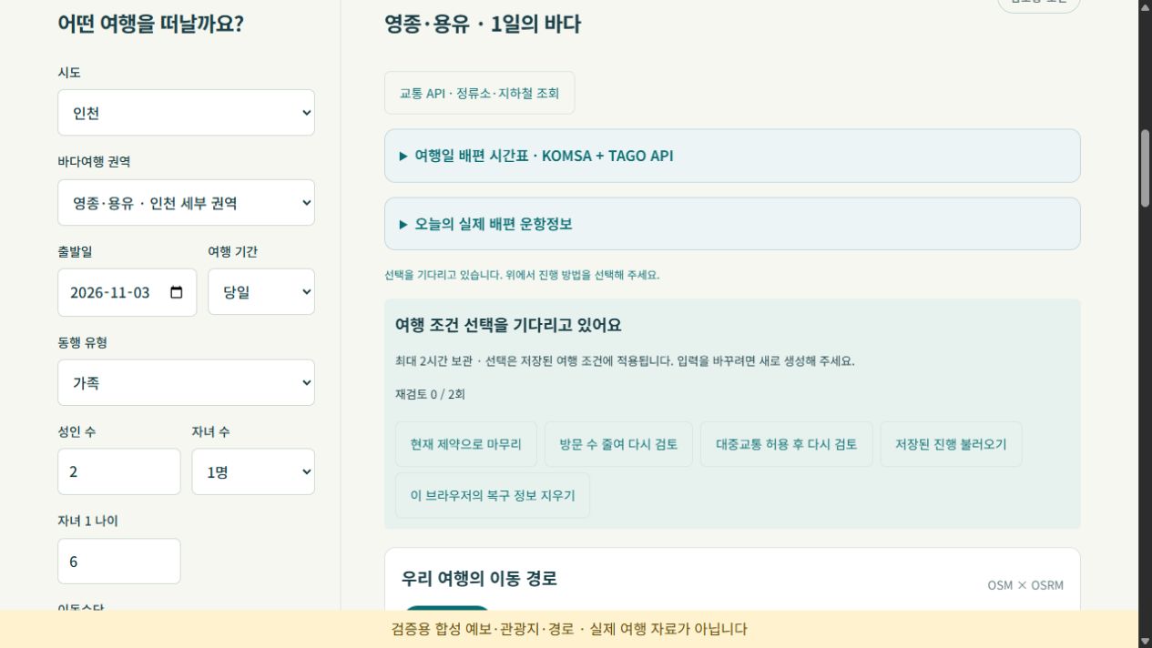
v0.9 connects LangGraph build → validate → traveler choice → recheck → finish to deterministic Python rules. At most two rechecks preserve fixed bookings; SQLite checkpoints and revisioned plans support recovery, n8n schedules collection, and Cytoscape/Langfuse expose filtered execution events.
Outputs & evidence
Provisional one- to three-day itineraries, map views, visit replacement and PDF exports.
v0.9 example · Synthetic weather, venues and routes; not live travel conditions
Scope Local prototype. Reservations and island access need separate checks.
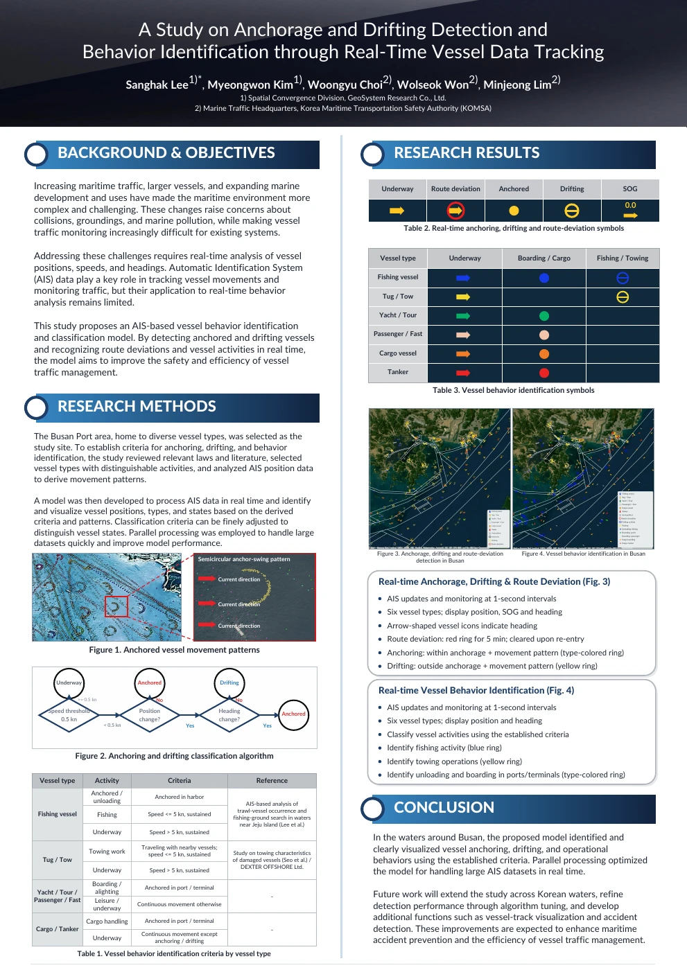
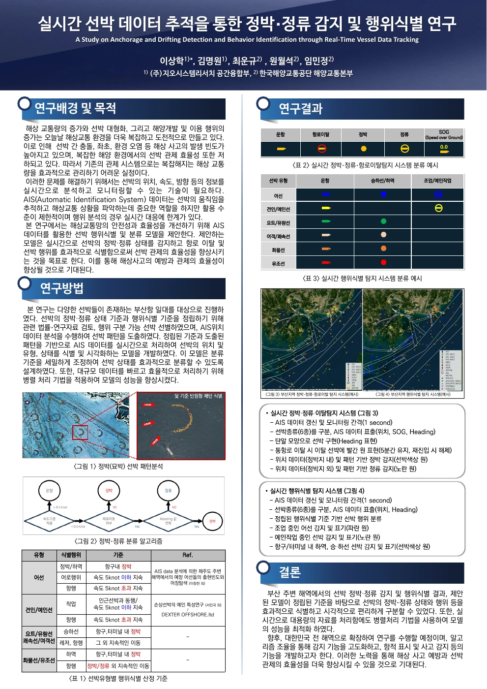
Anchorage, drifting and vessel behavior through AIS tracking.
A Busan-area AIS study combining position, speed, heading and spatial context to inspect anchoring, drifting, route deviations and vessel activity. Presented as a poster at the 2024 Fall Conference of The Korean Society for marine Environment and Energy; the supplied English translation is provided alongside the Korean original.
GeoSR · Professional research
My contribution Developed AIS preprocessing, spatial rules and parallel visualization; contributed the poster and presented the workshop.
English translation
Supplied translation of the original conference poster.
Qualitative poster examples and public-code validation have different scopes. Activity indicators are rule-based candidates; no labeled classification-accuracy benchmark is claimed.
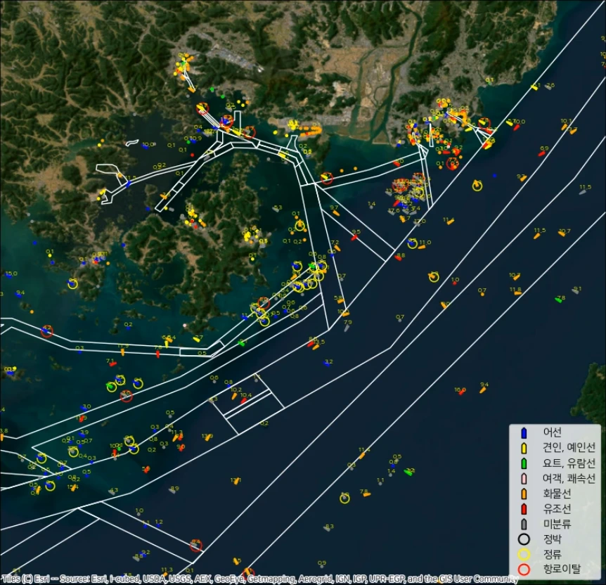
Presented on January 14, 2025 at the Technical Exchange Workshop for Maritime Traffic Network Operations and Management. The study uses 2022 Busan-area AIS observations to distinguish navigation states and vessel-type activity candidates and display them on a map.
Data and processing
Combine static vessel identifiers/types with time, position, speed over ground, course and heading. The presentation describes Python multiprocessing with ordered imap output.
Navigation-state rules
Combine position, speed, heading and fairway/anchorage context using literature and trajectory-pattern review. Study criteria include speeds below 0.5 knots, arc-like anchoring motion and linear/Z-shaped drifting patterns.
Activity by vessel type
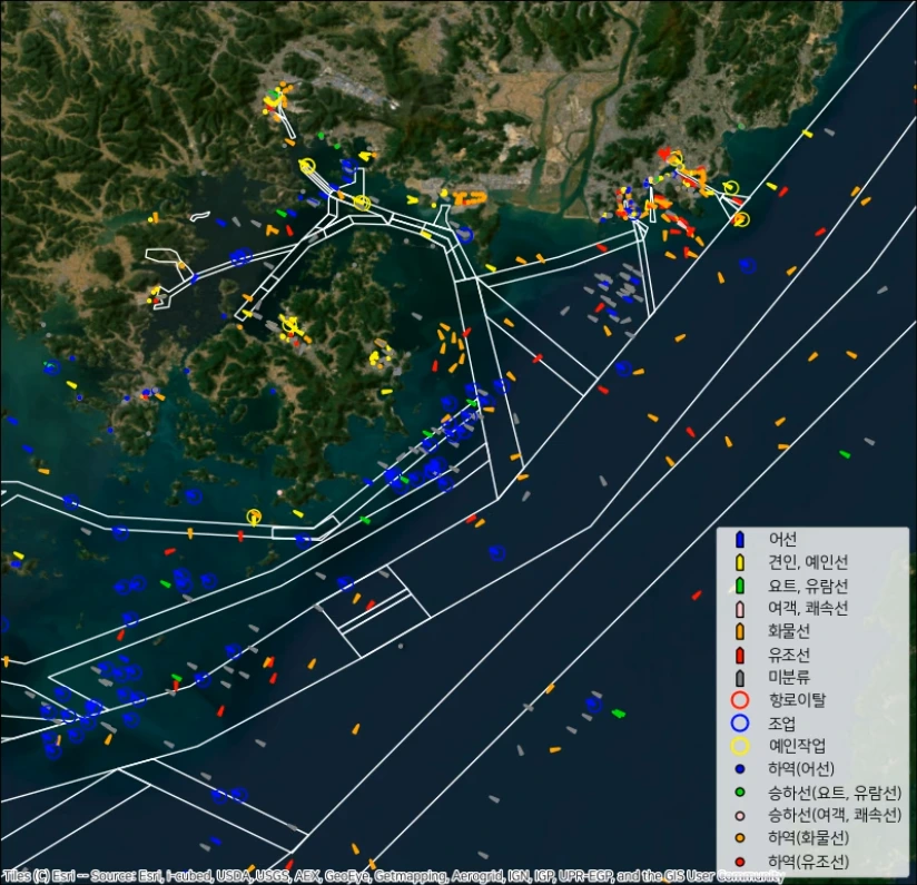
Apply criteria across six broad groups: fishing, towing/tug, yacht/cruise, fast/passenger, cargo and tanker vessels. Indicators use persistent low speed, port/terminal membership and proximity/co-movement.
Anchoring, drifting and fairway-exit indicatorsSlide 10 · Vessel-type colors, speed/heading and state symbolsVessel-type activity candidatesSlide 11 · Rule-based fishing, towing, loading and boarding candidates
Presentation settings and follow-up work
The deck describes a one-second display/update interval and a five-minute fairway-exit marker that clears on re-entry. Wind/current integration, richer drifting patterns, per-vessel trajectory displays and accident detection are proposed improvements.
These are research examples from the presentation, not evidence of a currently operating live service or measured classification accuracy. Activity indicators remain rule-based candidates; AIS alone does not confirm an operation or unlawful behavior. Original Esri and other basemap credits are retained in the images.
My contribution: processed and visualized climate data with Python and Fortran and refined the analysis through independent study and faculty consultation.
Black Sea SST and the Sahel.
Processed and visualized climate data with Python and Fortran to examine Black Sea surface temperature, Sahel rainfall and desertification.
Resolved unfamiliar Python processing issues through independent study and faculty consultation, refining the analytical workflow.
Received the 2020 University Innovation Support research-club Grand Prize on February 9, 2021, and later completed a statistics-department big-data analysis course.
At a National Meteorological Satellite Center summer camp, analyzed 20 years of NOAA SST data to examine ENSO and the number of typhoons affecting Korea, then presented the regression analysis to practitioners.
2021 / COAUTHORED UNDERGRADUATE THESIS
An Analysis of Global Mechanisms Associated with Winter Maximum Snow Depth and Snow Days in Jeonju
University · Coauthored research
My contribution Used Fortran and GrADS for processing, statistical analysis and visualization within a six-author thesis.
A coauthored 2021 undergraduate thesis from the Climate Modeling Laboratory, Department of Earth and Environmental Sciences, Jeonbuk National University. The study connects local snow observations with global ocean–atmosphere fields and examines statistical relationships and modeled atmospheric responses.
자료 / DATA
1983–2021 Jeonju observations
KMA snow depth and snow-day records, with NOAA SST, wind, 850 hPa temperature, geopotential height and sea ice.
방법 / METHOD
Seasonal means and lagged fields
DJF/three-month means, regression fields at 0–12-month lags and LBM response comparisons. My work used Fortran and GrADS for processing, analysis and visualization.
결과 / FINDINGS
Different signals for depth and frequency
The thesis reports an ENSO association at roughly eight months’ lead for maximum snow depth, with a weaker relation for snow days. LBM experiments compare atmospheric-response patterns.
The source specifies 1983–2021 and describes 38 years of analysis data. This summary follows the final thesis; it does not claim independent replication or validated predictive skill. The thesis has six coauthors, and the full modeling work is not attributed to one individual.
UNIVERSITY RESEARCH CLUB / SST & OLR
Sahel desertification analysis using SST and OLR
A collaborative university research-club presentation, with Sang Hak Lee contributing data processing, analysis and visualization. It explores Black Sea sea-surface temperature and Sahel climate relationships. The associated research-club work received the Grand Prize on February 9, 2021.
University · Collaborative research
Problem
Explore whether SST and cloud/rainfall indicators help describe Sahel climate variability and desertification conditions.
Inputs
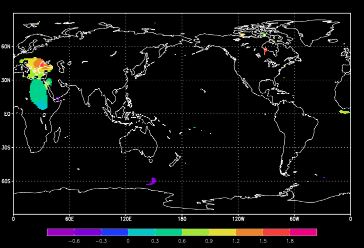
1990–2018 summer (JJA) SST, outgoing longwave radiation (OLR), precipitation and soil moisture, as specified on slide 6.
My contribution
Processed, analyzed and visualized climate data with Python and Fortran through collaborative research and faculty consultation. The deck is a joint result.
Implementation
Correlation and regression analyses connect Sahel summer rainfall with SST and OLR fields, then examine Black Sea SST and soil-moisture relationships.
Outputs & scope
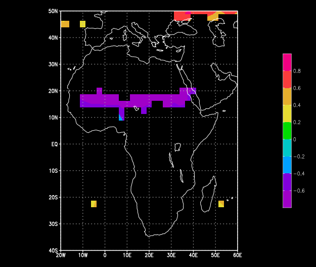
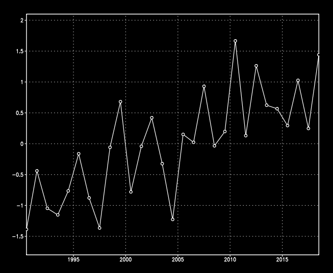
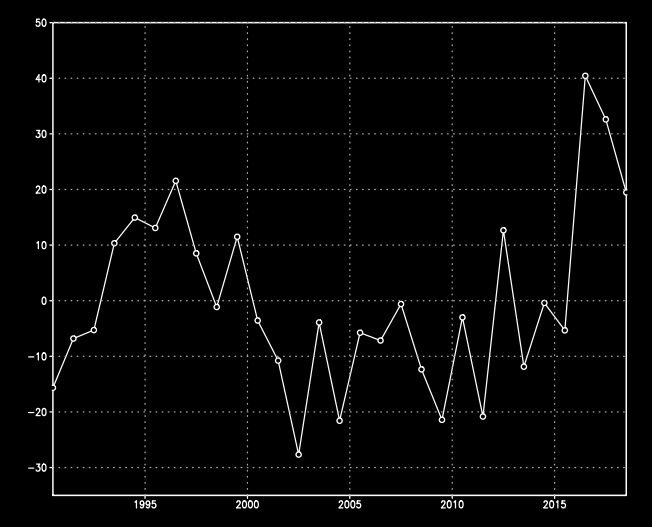
The presentation discusses SST relationships with cloud/precipitation patterns and a weaker soil-moisture relationship. These exploratory associations do not establish causality or validated predictive skill. Slides 13–14 discuss limits and potential Mediterranean/albedo follow-up.
Slide 8 · SST field using Sahel summer precipitationSlide 10 · Black Sea SST and summer OLRSlide 13 · Black Sea summer SST seriesSlide 13 · Summer soil-moisture series
Selected original figures from the supplied 15-slide presentation, with a source-based summary. Student identifiers from the cover are excluded. No new statistical execution or independent replication was performed for this portfolio.
Knowledge sharing · Careers
After Earth and Environmental Sciences: Working as a Data Engineer
39 web slides connecting ocean-data pipelines, AIS, big-data learning, AI-assisted project work and career preparation. A 50-minute talk plus 10-minute Q&A.
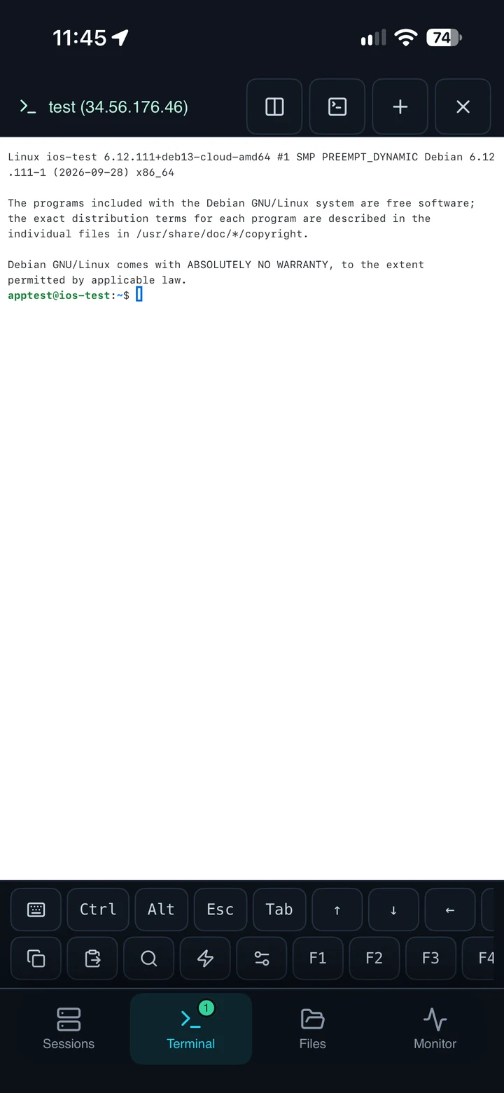
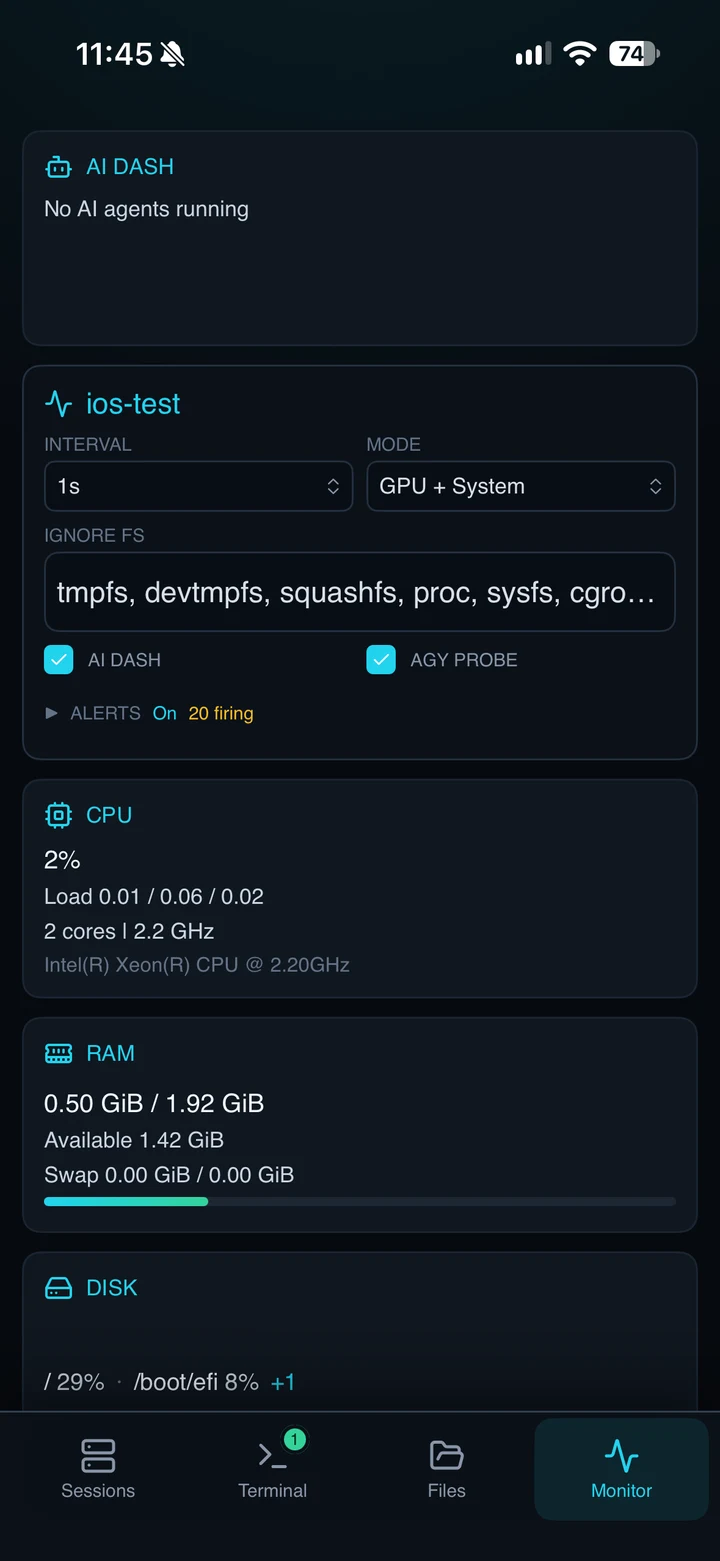
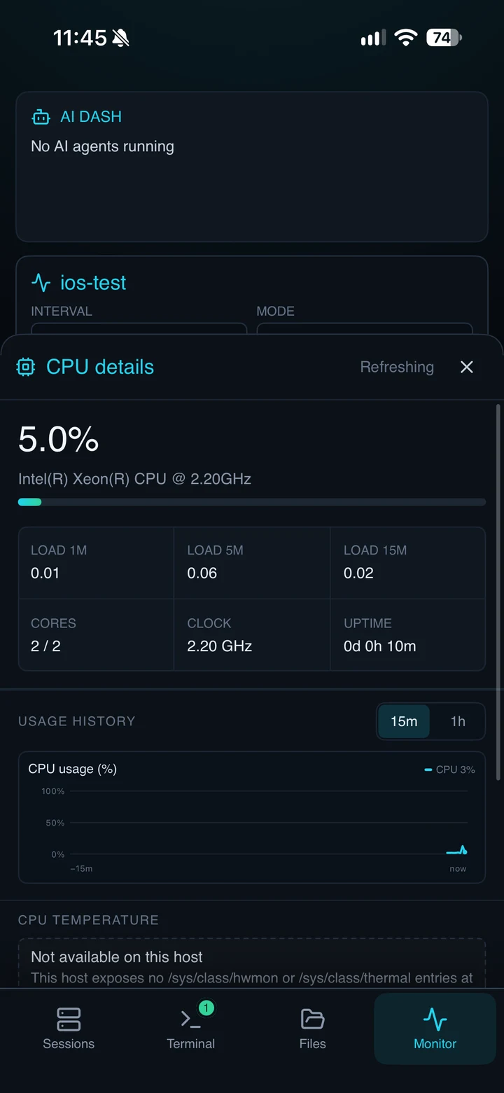
My contribution Developed native SSH/SFTP interfaces, monitoring views and Rust integration across mobile platforms.
GPUTERM
A remote compute workspace.
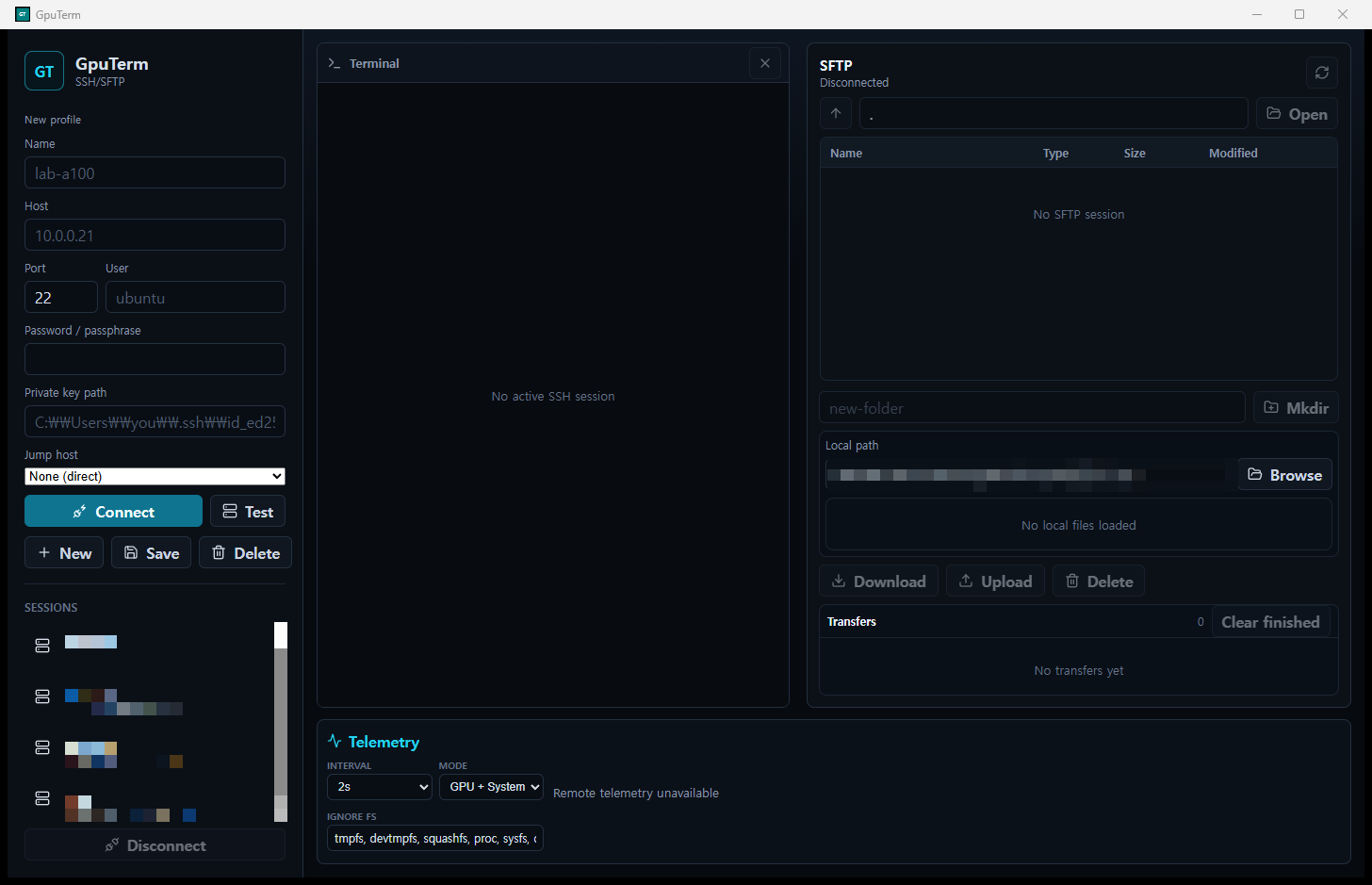
Work in SSH terminals, move files with SFTP and inspect system, GPU and LLM telemetry in one workspace. Rust-backed native mobile apps extend the workflow to iPhone, iPad and Android.
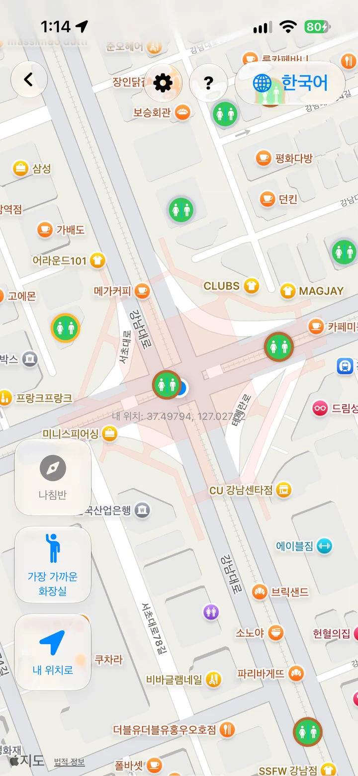
My contribution Developed native discovery/search interfaces and the Python-prepared local spatial-data workflow.
HELPPOOPY / KOREA TOILET MAP
Local data. Better nearby choices.
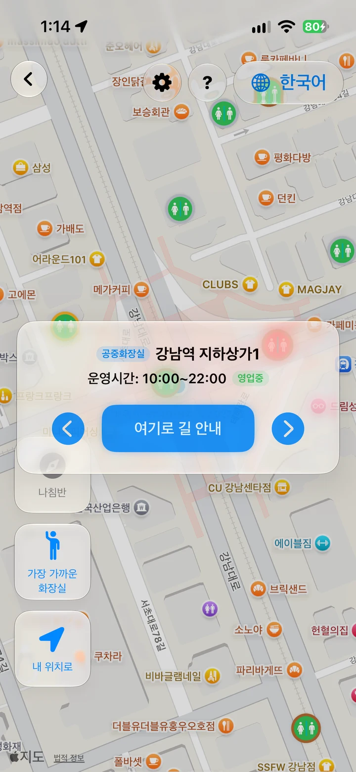
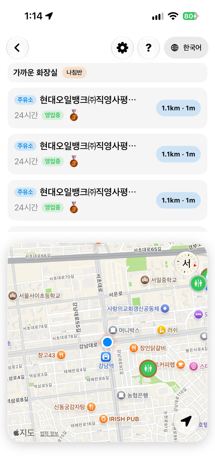
Pedestrian discovery and direction-aware driving search backed by a Python-prepared SQLite/R-Tree database. Weekday hours, precise-distance filters, localized interfaces and on-device translation turn records into a focused map experience.
Mobile source repositories and underlying datasets remain private. Screens show the iOS app prepared for App Store submission.
PRIVATE PROJECTS / NATIVE MOBILE
Private source. Publicly described engineering.
Five independent mobile implementations, summarized from the current private READMEs. Source code, credentials and underlying records remain private. These are implementation summaries, not a new runtime or release audit.
Independent · Private source
Pocket Weather Station
From device observations to inspectable weather information
Engineering details & contribution
Problem
Combine device observations and external forecasts in a personal weather tool with inspectable predictions.
Inputs
Device barometer, location/motion, WeatherKit/Open-Meteo forecasts, airport METAR observations and local climate context.
My contribution
Developing the SwiftUI app, observation processing, altitude correction, forecast fusion, verification views and Apple Watch integration.
Implementation
Minute-level observations and movement-aware quality checks feed pressure trends and rain likelihood. Pressure-flow maps and outdoor altitude profiles connect SwiftData records, CSV/ZIP export, CloudKit device summaries, widgets, Live Activities and Siri shortcuts.
Outputs & scope
Private development project, source version 0.1.0. Saved predictions support Brier/reliability and engine comparisons. Pressure-flow estimates are heuristic; no certified warning, medical decision or App Store release is claimed.
GPUTERM_IOS / PRIVATE SOURCE
GPUTERM for iOS
SwiftUI / Rust / UniFFI / SwiftTerm
Engineering details & contribution
Problem
Bring SSH, file transfer and server telemetry to iPhone and iPad.
Inputs
SSH sessions, remote/local files and host/LLM telemetry.
My contribution
Developed native workspaces and the SwiftUI–Rust bridge, including terminal/SFTP interaction, telemetry views and key-management flows.
Implementation
A UI-independent Rust core exposes commands through UniFFI. SwiftTerm powers the terminal; device Keychain entries hold credentials. Transfer queues, host-key review and iPad/external-display layouts support daily workflows. Discover remote web services on Linux/macOS/Windows and open them through temporary SSH forwards. App/credential locks and optional configuration sync keep passwords and private keys device-local. Siri/App Shortcuts expose server status.
Outputs & scope
Native terminal/file/monitoring screens and architecture, verification and release documentation. Remote monitoring depends on host tools, credentials and permissions; repository features do not establish App Store version parity.
Provide mobile and wider-screen remote-server workflows on Android.
Inputs
SSH profiles, SFTP operations, terminal events and server telemetry.
My contribution
Developed Compose workspaces, Rust command/event integration and native interaction and monitoring workflows.
Implementation
JNI connects the Kotlin UI to Rust SSH/SFTP and terminal state. Adaptive tablet/desktop layouts, parallel transfers, reusable keys, Keystore-backed credentials and monitoring history keep operations explicit. Discover remote web services on Linux/macOS/Windows and open them through temporary SSH forwards. App/credential locks and optional configuration sync keep passwords and private keys device-local. External-display sessions and folder-based sync extend the workspace.
Outputs & scope
Native Android app and documented build/verification procedures. Containers, Kubernetes and database monitoring require suitable remote tools and access. The README describes Play preparation, not a verified Play release.
Turn a local location dataset into focused pedestrian and driver search.
Inputs
Authorized restroom records, location/heading and weekday operating hours.
My contribution
Developed native discovery/search interfaces and the build-time spatial-database workflow, including opening-hour and direction-aware rules.
Implementation
Python prepares encrypted SQLite tables and R-Tree indexes. Viewport candidates receive exact-distance, weekday/overnight-hour and grade filters before display and Apple/Naver Maps navigation handoff. ML Kit supports on-device text translation. Current source adds rating requests after returning from directions and a direct Settings rating entry.
Outputs & scope
Native map modes and repeatable data preparation. The current README reports an app build but unresolved unit-test target dependencies. Bundled encryption discourages casual extraction; it does not ensure dataset secrecy.
Kotlin / Compose / Google Maps / SQLCipher / R-Tree
Engineering details & contribution
Problem
Find relevant nearby restrooms while preserving the distinction between distance and route guidance.
Inputs
An authorized local restroom database, map bounds, heading, hours and grade filters.
My contribution
Developed Compose map/search flows and native local-data access, adapting the pedestrian/driver rules to Android.
Implementation
An encrypted R-Tree viewport query supplies candidates; precise distance and opening-hour checks refine them. Driver mode uses a forward 180-degree field, a 15 km nearby search and a conditional 50 km open-location fallback. Navigation hands off to installed map apps.
Outputs & scope
Native pedestrian/driver modes, a 15-language UI and JVM search-rule coverage. SQLCipher/index behavior still needs device instrumentation. Geographic distance is not road distance, and no Play availability is claimed.
I am a Data Engineer at GeoSR, working with marine and meteorological data since February 2023. My work connects scientific processing, forecast verification and geospatial analysis with operational services.
How I work
Define the contract
Make schemas, coordinates, units and time semantics explicit.
Keep decisions inspectable
Use readable rules, traceable checks and documented assumptions.
Respect the evidence
Distinguish data conformity, heuristic candidates and domain accuracy.
Credentials
Engineer Meteorology · 기상기사
Engineer Ocean Environment · 해양환경기사
Weather Forecaster License · 기상예보사 면허
B.Sc., Jeonbuk National University
Earth and Environmental Sciences · 2016–2022
05 / EXPERIENCE
Education, service and professional experience.
Explore education, police service, reserve affiliations, professional work and honors across time.
Education, service and career Gantt chart
Select a bar to explore the related experience. Dates are shown beside each entry.
As of October 2026. Education and reserve affiliations use the supplied year ranges; they do not establish monthly enrollment status or continuous active duty. Awards mark individual dates.
Career milestones
GeoSR
Data Engineer · Marine & meteorological data, forecast analytics and geospatial workflows.
Korea Meteorological Institute
Research Intern (주임연구원) · R&D Planning Division.
Weather-technology and policy research, monthly newsletters, quarterly reports and division administration.
219th Company, Seoul Metropolitan Police Agency
Police service · Discharged as Police Sergeant (수경).
Embassy and facility security; protection of critical national infrastructure and events; VIP protection.
Crime-prevention patrols, demonstration and assembly management, and traffic control.
Counter-terrorism and counter-espionage operational duties.
Platoon administration and service as a platoon radio operator.
Jeonbuk National University
B.Sc., Earth and Environmental Sciences · 2021 coauthored thesis
Selected contributions summarized from the 2023 work record and the 2024–2025 annual work reports.
Professional summaries follow the supplied work records. Linked public repositories show related implementations and their own validation boundaries; they are not a release of internal work reports or datasets.
2023.08–2024.01 · Marine spatial monitoring: collected and analyzed industry indicators, including port cargo-throughput growth and cruise-berth utilization, and contributed case research and proposal writing.
2025–2026 / DATA ENGINEERING
Scientific data, end to end.
GeoSR · Professional contribution
Problem
Recurring scientific files need consistent checks and recoverable processing.
Inputs
NetCDF and representative-value CSV files, supplied specifications and database schemas.
My role
Built offline validation, spatial-output and PostgreSQL ETL workflows; wrote specifications and test documentation.
Processing & operations
Python/Shell/Docker file monitoring; schema changes, upserts and transactions; scheduling, reprocessing and processing/error history.
Outputs & evidence
Field-level reports, GeoTIFF previews, current-vector CSVs and database updates. The related public repository documents implementation and scope.
Interpret vessel movement in context without treating heuristic labels as confirmed activity.
Inputs
Historical Busan AIS positions, speed and heading, vessel metadata and fairway/anchorage polygons.
My role
Processed trajectories and developed spatial rules, time-aligned detection and visualization; contributed the poster and delivered the workshop presentation.
Processing & operations
GeoPandas spatial recognition, multiprocessing and rule-based anchoring, drifting, route-deviation and activity indicators.
Outputs & evidence
Map examples, the 2024 conference poster and 14 January 2025 workshop deck; public-code differences are documented. Activity candidates require independent confirmation.
Explain changes across forecast products and support recurring service review.
Inputs
Observation, forecast and service records, old/new model products, weather warnings and website/OpenAPI usage records.
My role
Performed Python/Fortran comparisons, change-factor statistics and recurring reports; supported monitoring, incident response and server setup/migration.
Processing & operations
Group by activity, location and period; summarize unusual-weather days and usage; retain the basis for report calculations.
Outputs & evidence
Monthly statistics, summaries and utilization analyses. The linked public code covers product comparisons; it does not establish observation-based forecast skill.
Research emerging weather technology. Communicate what matters.
Research Intern (주임연구원) · R&D Planning Division, Korea Meteorological Institute
Problem
Turn scattered weather-technology and policy references into timely R&D planning information.
Inputs
Domestic/international technology and policy news, literature, consultation materials and national R&D briefings.
My role
Researched and organized references, took a leading role in newsletter preparation, proposed report topics and supported division administration.
Processing & operations
Reviewed sources and reported findings to the division head; collaborated on a weather-and-autonomous-driving report after a topic change; participated in satellite-development consultations and R&D briefings.
Outputs & evidence
Monthly technology newsletter contributions, a quarterly report delivered by the deadline, and organized reference materials. This summary follows the owner-supplied career narrative; internal documents are not published.
GITHUB / LINKEDIN
Let’s talk about useful data systems.
Explore my implementation notes on GitHub, or connect with me on LinkedIn.